My wife, following her time at the EPA, has often been heard to say “it’s the water that will kill you”. While I believe she is, ultimately, correct in the case of the many poor souls that will ultimately fall victim to the effects of long-term accumulation of toxic and/or otherwise harmful substances in their tissues and bodily fluids, we were recently reminded by the WSLCB (link) that what is in the soil can be harmful, as well.
CORCs (Consumers of Regulated Cannabis) in Washington state have yet to hear anything of substance regarding this issue from the WSLCB, but GORCs (Growers of Regulated Cannabis) in Washington state got an earful on April 6th , when the Chief of their Enforcement and Education Division educated them all about (to use her words):
I am writing to notify you of an emergent issue in Okanogan County regarding pesticide contamination.
LCB Enforcement and Education staff have identified a pattern of pesticide testing failures that point to product contamination in a specific region of Okanogan County.
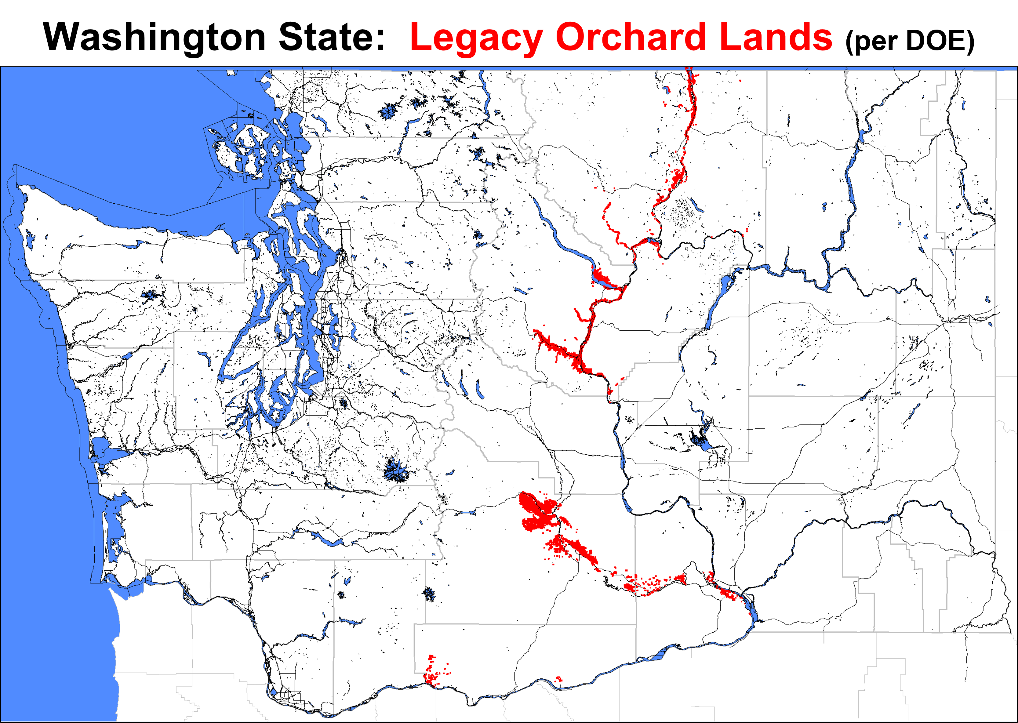
I imagine this caused quite a bit of concern up in the Okanogan. The original LCB map (linked above) showed a map with only four geographic references —- roads called “Pit Road”, “Old Highway 97”, “Highway 97”, and a business called A-Z Storage (note – I suppose that is a subtle warning from the LCB that you may want to be cautious if storing food in A-Z for any length of time).
What was missing from the map was anything indicating where the farms were in relation to these LOLs (Legacy Orchard Lands). However, our focus was clearly placed on the red box. That was, presumably, the area of concern and the area of the LCB’s focus going forward.
Today, I am going to share with you 11 more detailed maps that show not only the location of LOLs, but also the approximate (and often quite precise) location of all 1,026 GORCs licensed as of April 25, 2023. I’ll add a bit of context-setting text, but this is meant more to be a tool for GORCs to identify where they sit, relative to LOLs. That should help them to decide the wisdom of conducting soil and/or water tests on their land and whether or not they feel that a test for heavy metals might be appropriate in some of their finished product.
I will emphasize one thing (and then get off my bandwagon for today): the use of lead arsenide was very common across many of the LOLs in this state. It was sprayed extensively and it’s two components (lead and arsenic) are both heavy metals that are very PERSISTENT in the environment and that are very PERSISTENT in one’s body if they should somehow find their way into one’s body. I will also emphasize that little good and quite a bit of bad can happen when ENOUGH of either of these heavy metals has found it’s way into one’s body.
For those interested in the history of pesticide use on LOLs, this link may be something you find useful. It focuses on lead and arsenic, but pesticide use — in general — is the issue raised by the LCB’s recent actions. DDE (and DDD) are what they have found in the “Brewster Cluster”. These chemicals (which, as a family, I will refer to as DDx) result from the breakdown of DDT, a pesticide whose use was banned in the early 1970s in part because it was leading to a rapid decline in the population of America’s favorite bird — the Bald Eagle.
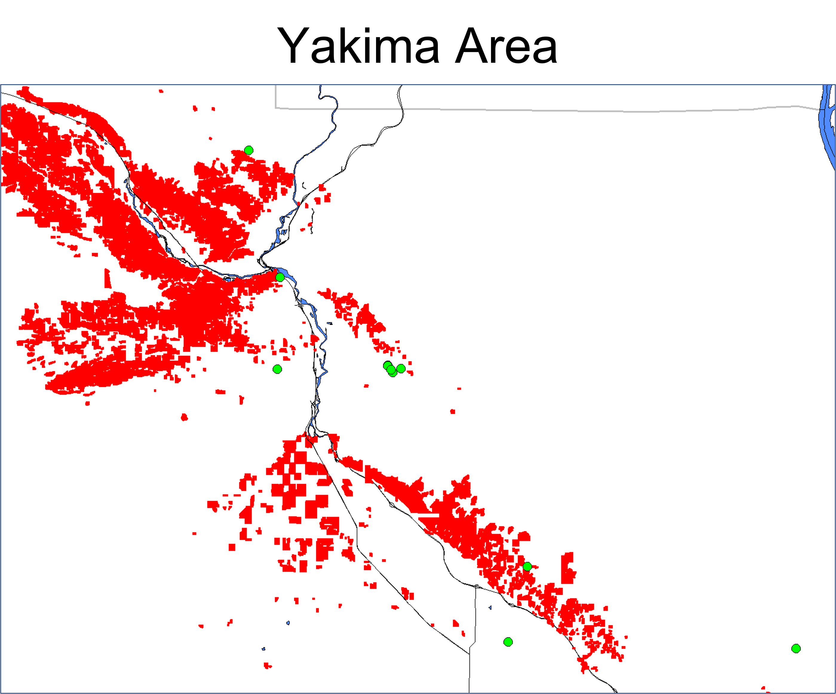
Here is a map of the “Brewster Cluster” which includes the approximate (and often precise) locations of the GORCs in the area. For geographic reference, all maps today also include major highways (unlabelled) and bodies of water (also unlabelled). The farms are all unlabelled, as well. The farmers know who (and where) they are, but this should help any of them that are trying to figure out where they are situated, in relation to these LOLs.
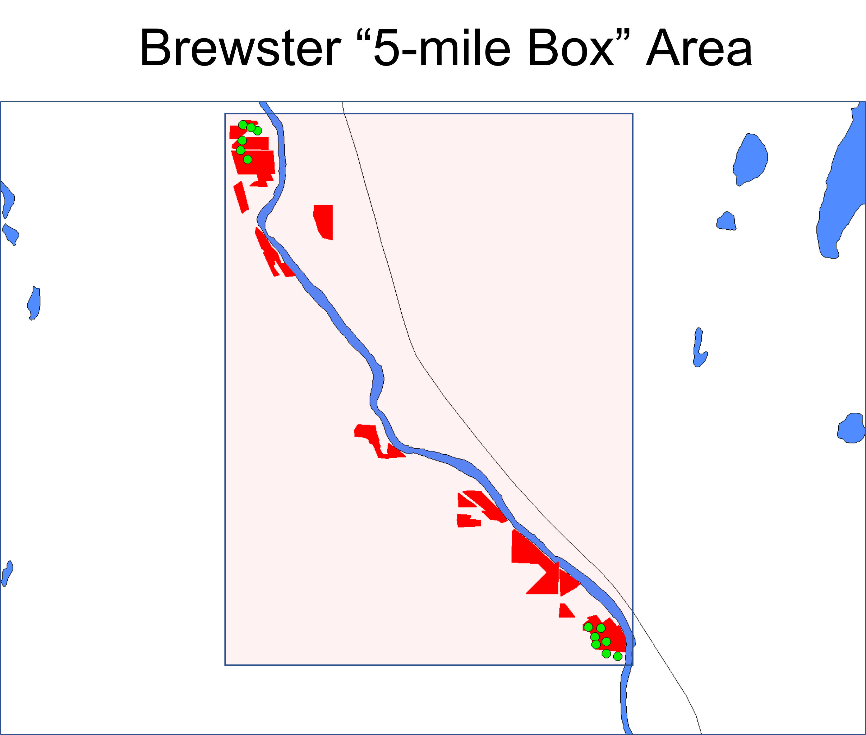
I got confused when I first started looking into this, as this was not even in Brewster. It’s actually a bit north of the town of Brewster. Here’s a similar map, but including the entire greater Brewster area.
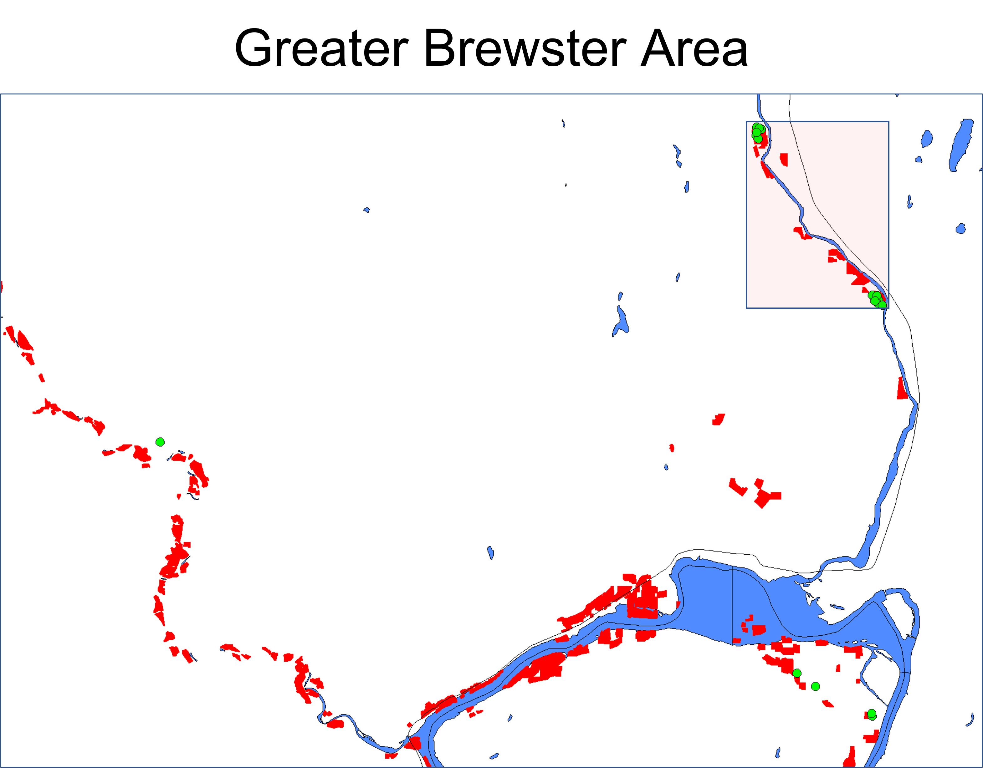
As you can see, it’s NOT just the 5-mile box that may be a problem. To that end, here is a copy of the state-wide LOL map (with LOLs colored red) that includes all licensed GORCs as little green dots.
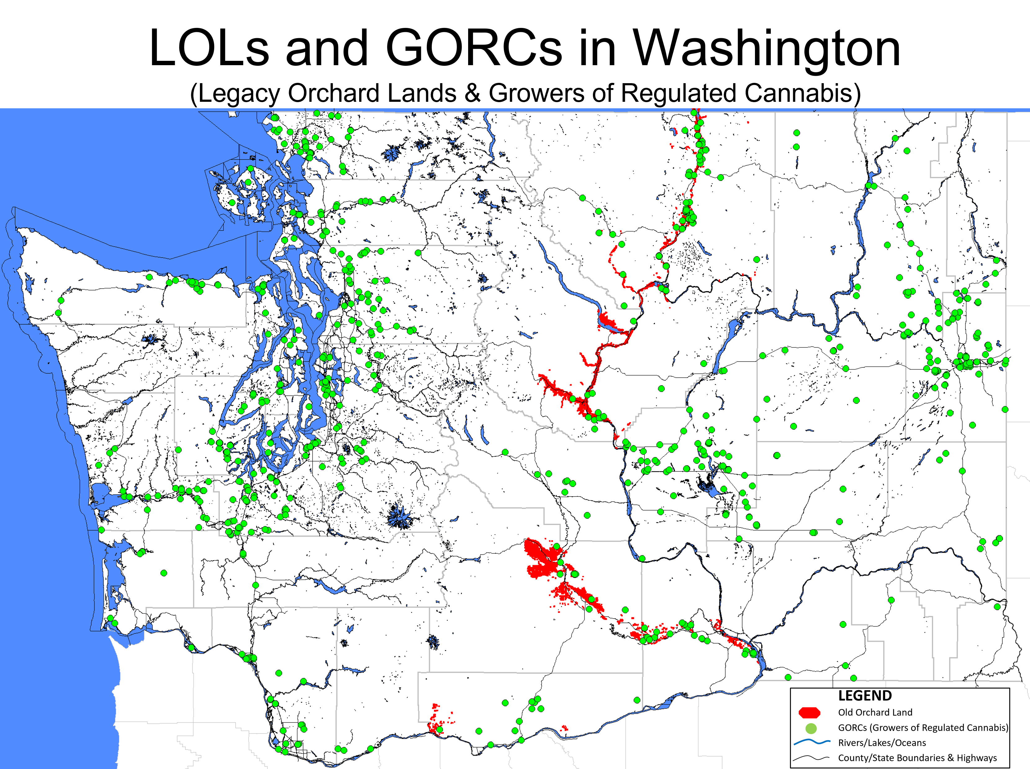
Having GORCs in close physical proximity to LOLs is, clearly, not limited to the Brewster area. Starting at the northern boundary with Canada and working our way south, here are a series of maps zoomed in such that GORC locations and LOL locations can be readily evaluated.
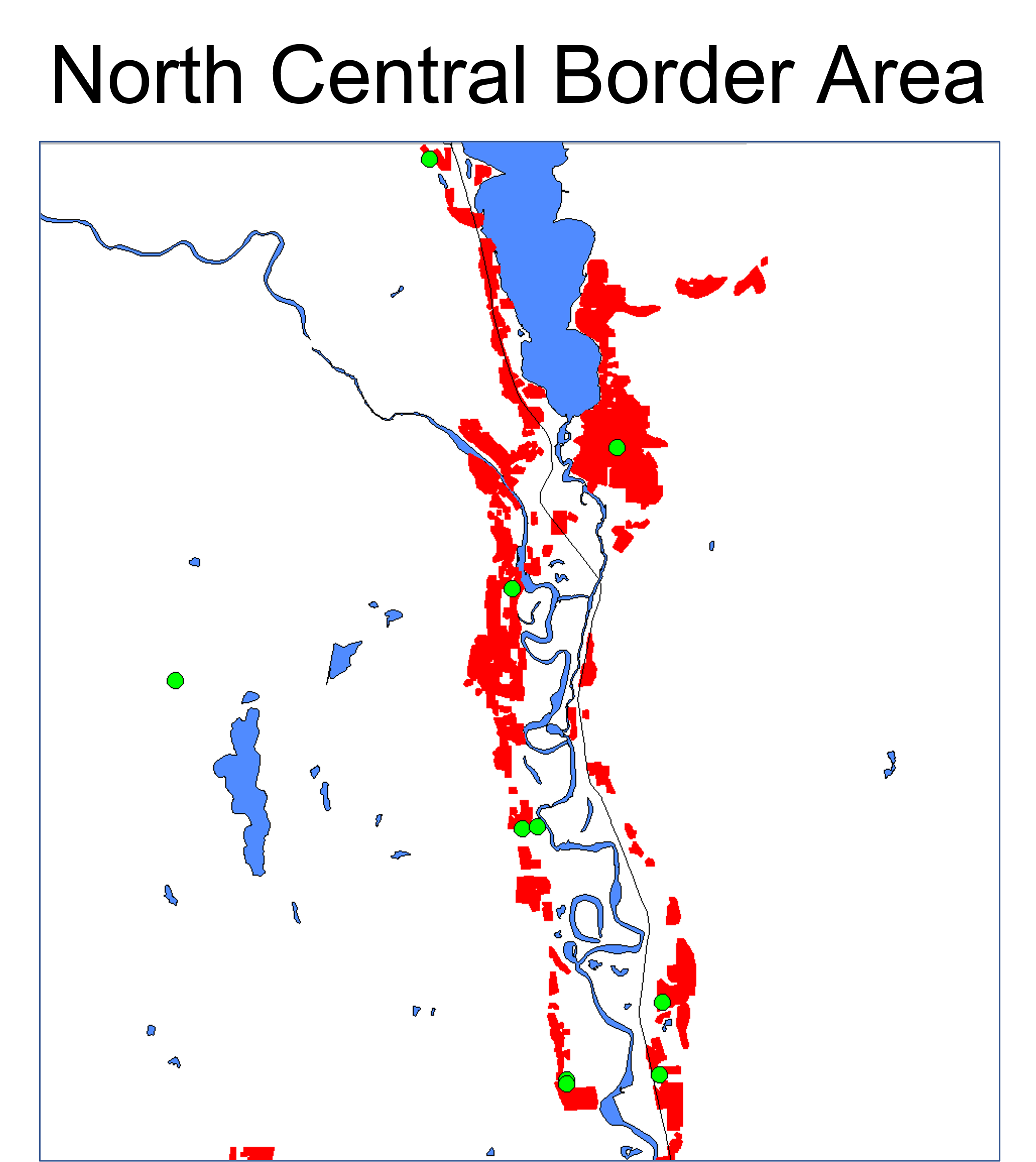
Might be some proximity issues there.
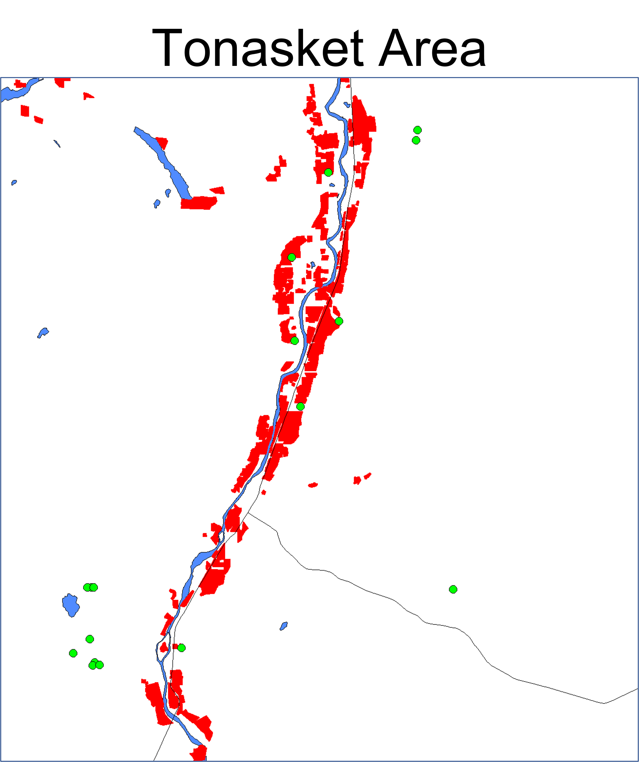
There, too …. from the looks of it.
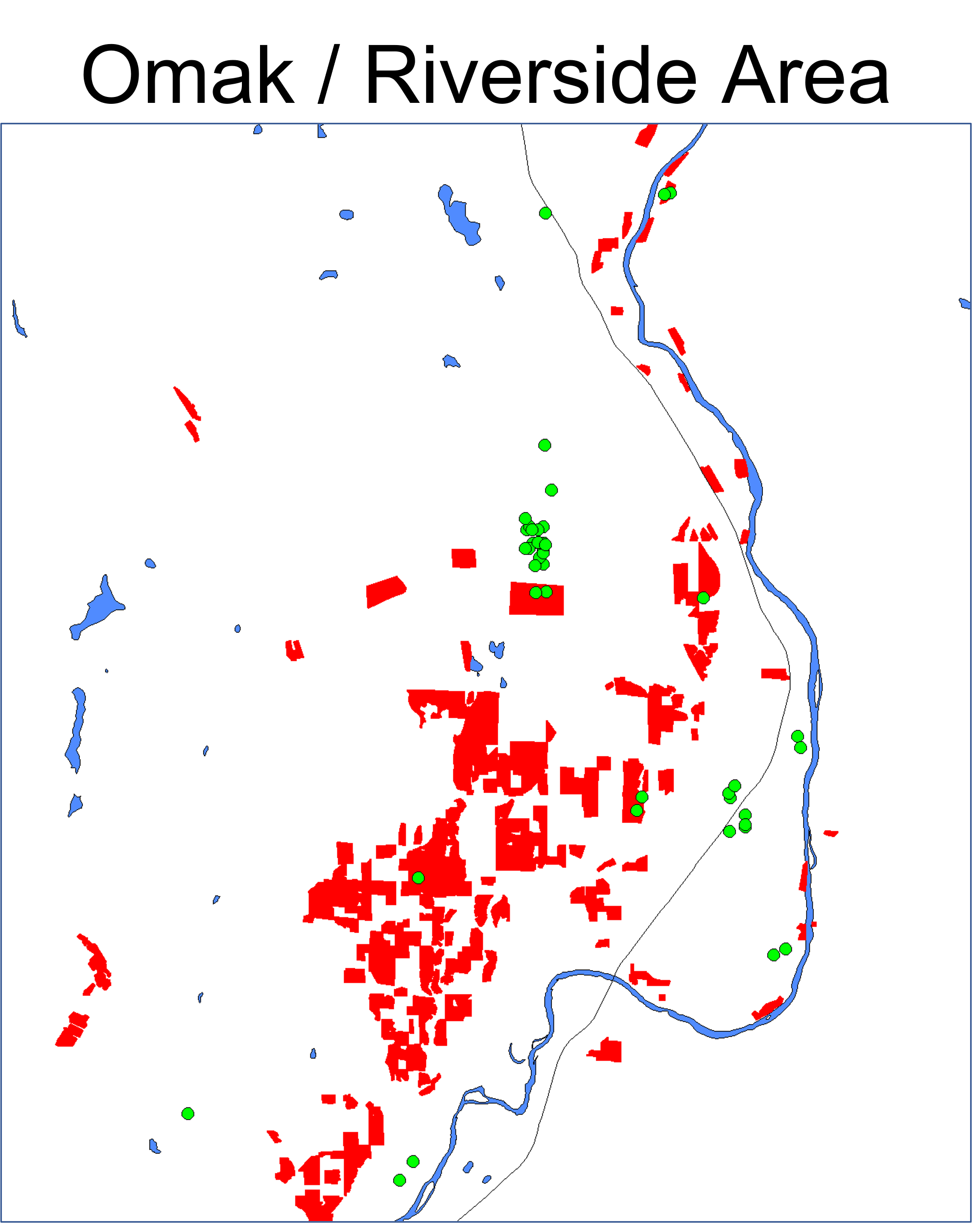
Definitely some proximity issues there. Okanogan County for the WIN!
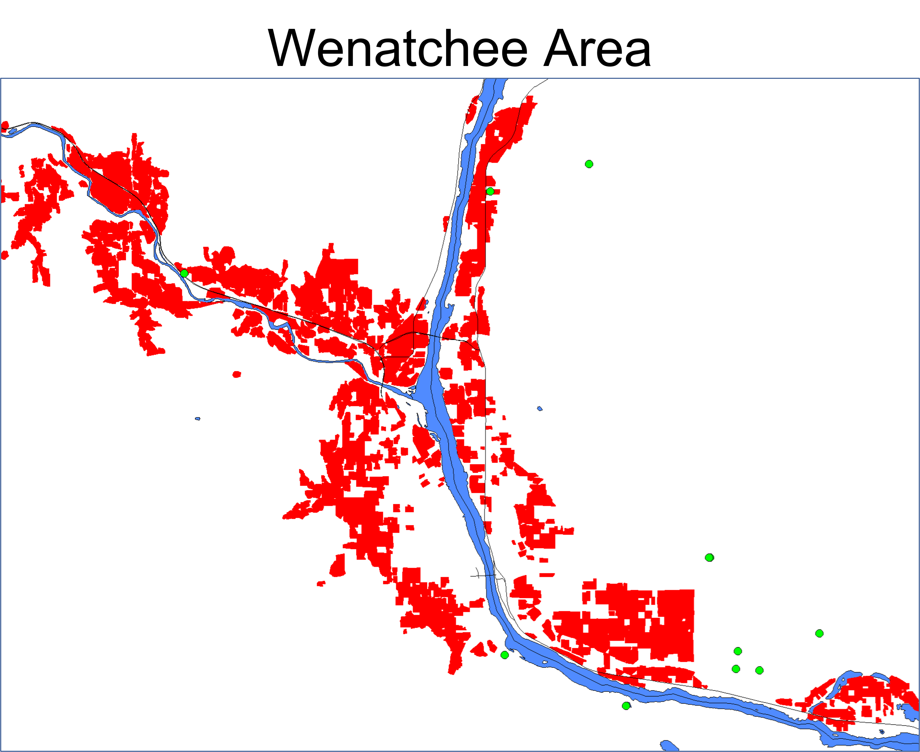
Lest we settle into the mindset that this issue is limited to Okanogan County, look at these maps.
I had NO IDEA that the hops that go into the beer that I enjoy so much are largely grown in an area with so much red soil. I wonder if the LCB will begin having beer (or, at least beer with a high concentration of hops — commonly called IPA) tested for DDE — or heavy metals?
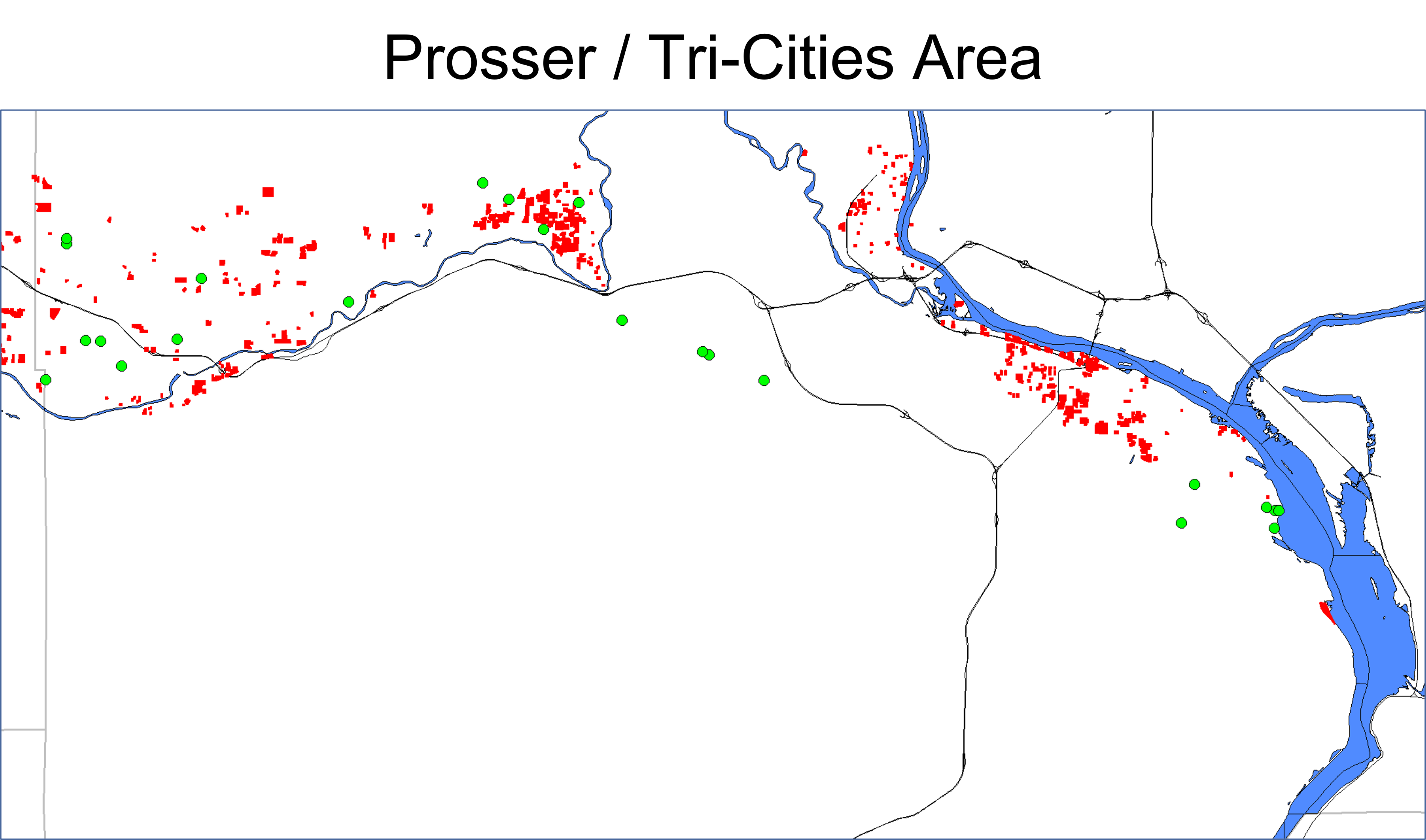
Prosser and Tri-cities — I am surprised how much GORCing is going on in this area, given how difficult local jurisdictions have been over the years with respect to cannabis retailing.
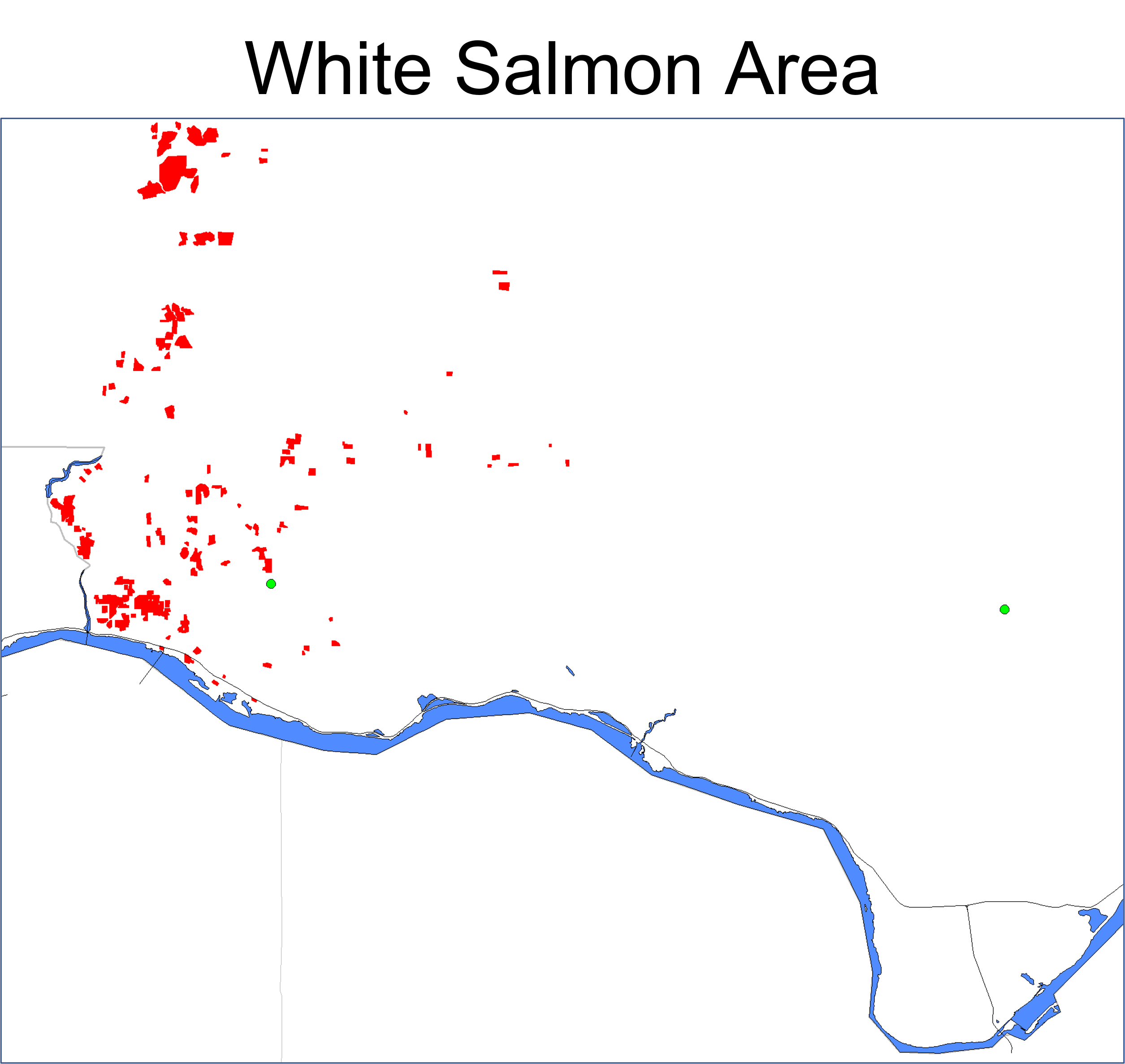
Not much happening down there, but one of the GORCs is reasonably close to a cluster of LOLs.
To that end, I would advise all farms that think they might be close to LOLs to do some testing. There are helpful resources easily accessible through the DOE (see my link above, for a good starting point) that should assist with soil and/or water testing efforts. Heck, the LCB may even do some on your land for free — although I don’t know if you’d like the result if they were to find a problem with your land. Just ask the farmers in the Brewster Box. I would also advise that any GORCs that fall on (or close) to LOLs consider having some of their flower and some of the concentrates (if any) made from their flower tested for heavy metals contamination. This can be done with either of the the two best (In my opinion) I-502 cannabis testing labs: Medicine Creek Analytics in Fife (near Tacoma) or Confidence Analytics in Redmond (near the Black Raven brewery). They are the only two remaining I-502 testing labs that have made the investments necessary to be able to test for heavy metals.
Seriously, if I were in your shoes (GORCs on top of — or in near proximity to — LOLs), I would run some product down to one of these labs to get heavy metals testing done TODAY (or, at least, this week). I’d also look into how to get DOE out to test my soil and water for heavy metals and legacy pesticides.
The REASON I’d do that is that it is likely better to be proactive on things like this, rather than having the LCB eventually figure out which GORCs are the little green dots that are on top of LOLs (or close to LOLs) and having them show up one Friday evening to destroy my crop, seize my inventory and put my business on “administrative hold” until such time as they figure out next steps.
Later today, I’ll be sending e-mails out to the 157 farms in the table that follows. There will be one version going out to the 29 farms that appear to sit right on top of legacy orchard lands. There will be another going out to those not ON TOP OF the LOLs, but within approximately 1,000 feet of at least one LOL. There will be a third version going out to the farms not within 1,000 feet, but within one mile of at least one LOL. I chose 1,000 feet as one “buffer”, as the LCB seems to think “bad” things should stay at least 1,000 feet away from “good” things. I chose 1 mile as a second “buffer” after speaking with a friend knowledgeable about legacy pesticide application methods and the likely spread of what was applied.
That gives at least these GORCs the chance to be proactive on this issue. That will be important, I suspect, for those that have not ALREADY been proactive on this issue.
I also plan to submit a Petition for Rulemaking to the WSLCB this week to include Heavy Metals testing in the suite of standard, required I-502 Quality Control (no longer Assurance … just control) testing. I’ll keep readers of HI-Blog apprised of the status of that as it gets evaluated.
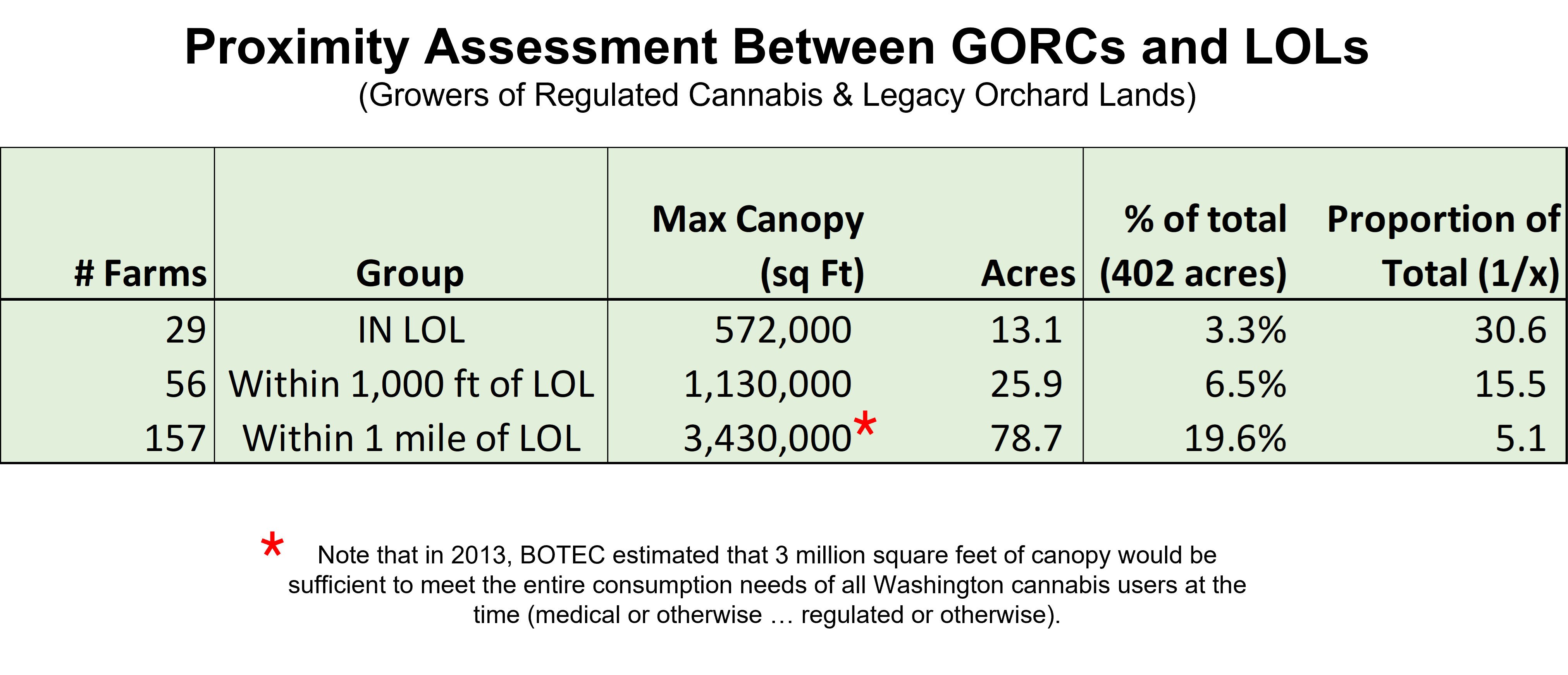
To CORCs, you pay LOTS and LOTS of taxes for “clean” cannabis from state-sanctioned stores. It should be “clean”. These data suggest that, in some ways, it may not be “clean”. If it is not, the impacts on the health of CORCs may not be seen for decades, if ever. They will, however, exist. With almost 2,000,000 folks purchasing at least some of their cannabis from retail storefronts and with almost 20% of the licensed canopy in this state falling within approximately one mile of legacy orchard lands, the number of people potentially exposed to things left behind on those legacy orchard lands and the surrounding environs is likely measured in the hundreds of thousands.
THAT is a cluster of potential contamination worth regulatory concern.
It is almost criminal if growers in these areas HAVEN’T long ago done extensive testing to determine if they suffer from contamination. It is not like it wasn’t (and isn’t) commonly known that the risk in these areas is high and particularly for a bio- accumulating plant like cannabis. If I were a buyer and cared about my customers I would immediately stop buying from the subject grows until I had proof positive that they were contaminate free. I would also have a long and hard converstaion as to why these growers had not done such testing right from the get-go (if they haven’t).
There is NO excuse for growing in these areas and not testing to ensure one is not poisoning one’s customers.
This is a big issue and the state should take action immediately. We can only hope they are moving expeditiously now that they are aware. It is indicative of the siloing of information that WSLCB seems to have been blissfully unaware of the issue when many state agencies have been actively involved in mitigating these risks for decades! No excuses here either.
I forgot to thank you for doing the work to locate the grows of interest in the risky areas. That is a very sueful service and I hope people appreciate it.
Thanks
Thank-you, Steve (assuming you mean useful and not “sueful”).
I don’t know if it’s criminal to have not previously tested the soil. I do think it could reasonably be considered a confusing omission, though.
Megan insisted that we test the soil in what was to be our vineyard before we put an offer in on the land. The tests certainly helped in amending the soil appropriately for the crop in question.
I hope you are doing well. I noticed the new “north” facility while working on pinpointing farm locations for this project. Is that out by the lake you took me to? The facility looks stunning, by the way.
Original author here:
I woke up to a response to one of the e-mails I sent out late last night to the 157 farms I identified as being on or within one mile of legacy orchard lands. It was a nice e-mail that informed me that:
“we grow above ground in imported clean soil on top of ground fabric & use lovely fresh river run off straight from the beautiful north cascades mountains”.
I thought that should be shared here, as a reminder that there are growing techniques that would be expected to mitigate any ground-based (or water-based) contamination that MIGHT be in an area. The courteous farmer describes, in the words quoted above, an approach to cultivation that would be expected to minimize any soil-based (or water-based) contamination associated with the nearby legacy orchard land(s).
It has been my fairly consistent experience that those who choose to grow cannabis for a living tend towards being good people with good souls and good intent.
To that farmer (and many others): good growing this season and beyond!
I appreciated your note.
Original author here, as well:
I’ve heard back from a number of farmers who are, generally, appreciative that I shared this information with them. Most have added that they have either already had their soil and/or end-product tested for legacy orchard contaminants OR that they grow in a way that any potential contamination in the local soil is unlikely to find it’s way into their plants.
Good on them. ALL of that feedback was (and is) appreciated.
I have also heard from one farmer whose farm(s) sit directly on top of a legacy orchard identified by the DOE. This farmer challenges the DOE designation of his land as once having nurtured an orchard and he believes that I should trust his word over the authoritative source on the issue (the DOE). This farmer also seems to have gotten a bit frustrated that I am unwilling to take him at his word and retract my supposedly vile post.
I am, of course, inferring his frustration, as we never really know what is going in in someone else’s head. This farmer lashed out at me with a decidedly negative ad hominen attack that suggested (among other things) that I might be on the payroll of either labs or indoor growers and, thereby, be trying to increase testing and/or mess with outdoor growers for profit.
For the CORCs that read my Blog, I’d suggest that you take a look at this farmer’s comments on the original FB post last week that linked to my post on proximity of regulated cannabis farms with DOE-identified legacy orchard lands. I’d then suggest that you think a little about what his comments and stance seem to imply about how he views his own self-interest in relation to the safety of the consumers of his product (and, for that matter, the product of other farmers potentially impacted by legacy orchard lands).
It’s always good to think before buying, anyway. Know your farmer. Know what they are like. Preferably, go with farmers that you trust.
I tend to embrace inquisitiveness and doubt. However, I really have no time for self-serving rude ad hominen attacks.
Until such time as I hear differently from the DOE and/or they change the maps that they have produced showing the location of legacy orchard lands, I will be changing nothing with respect to the work I have already published on this issue. 99 Greenacres Road is shown to sit directly on top of Legacy Orchard Land, and so it shall be until the DOE says otherwise.
To help things along, particularly since the farmer that is sitting on top of that particular DOE-identified legacy orchard continues to “yell” online that he is being screwed by inaccurate data (that I have, apparently, “weaponized” against outdoor growers), I have taken the liberty of informing the DOE about his concerns with their map of legacy orchard lands and, specifically, the one that is sitting under the address of his farm.
If I become aware that they have updated their Legacy Orchard Lands map, I will try to get a copy of the new one and incorporate it accordingly.
If not, then his online blathering thusfar about this issue will come to seem even more likely to be self-serving and disingenous than it already does.